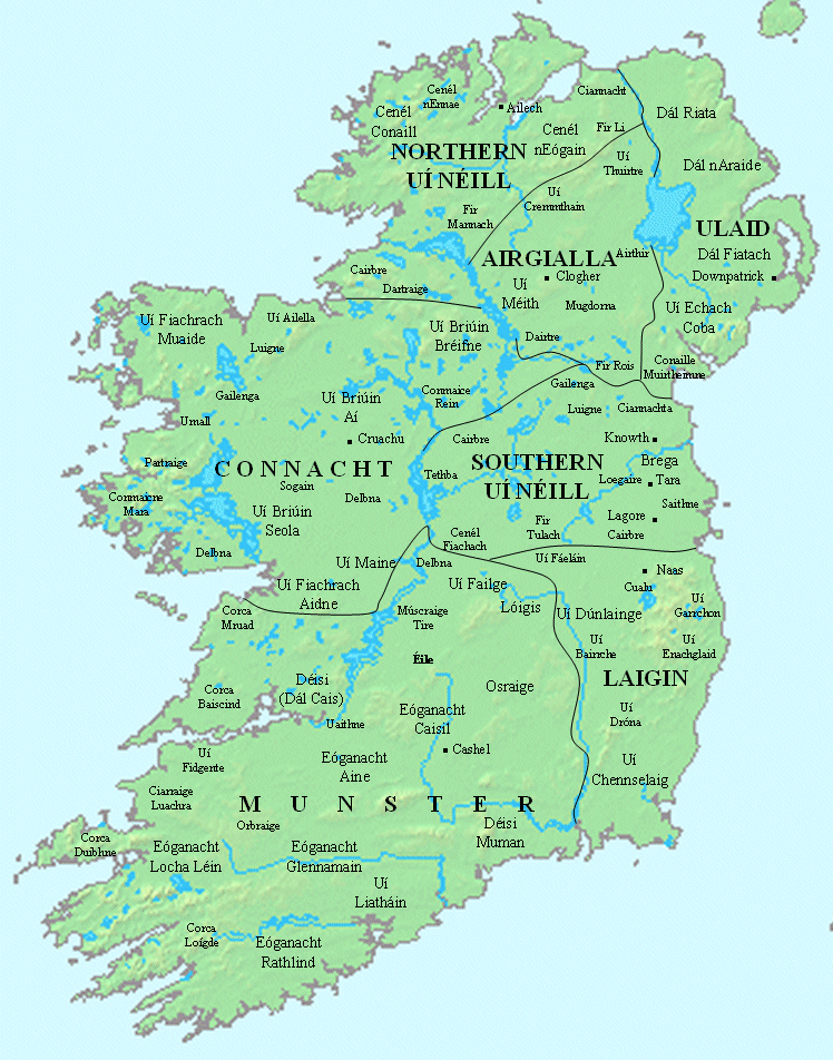
The Ulster Kingdoms

Now we turn to Oriel, or Airgialla, centred on Clogher, the land of ultimate origin of the great Campbell clan of Argyll. The name Clochar refers to something made of stone (‘Cloch’ is the Gaelic word for ‘stone’ and can be anglicised as ‘cloch’, ‘clogh’ or ‘clough’). Archaeological remains from before the 5th century have been found in the vicinity. Clogher was an important ancient ritual site of the Ulster Cruthin/Pretani, before being conquered by the Gaels. It is said to have been the location of a gold-covered oracle stone named Cermand Cestach. The story goes that “Cloch-Ór (Golden Stone), may have been a ceremonial or oracle stone originally covered in gold sacred to the ancient British Pretani…given to Mac Cairthinn by an old pagan noble (Cairpre, the father of St Tighernach of Clones, who had harassed him in every possible way until the “saint’s patient love won the local ruler to the faith.”
The stone is recorded as being “a curiosity in the porch of the Cathedral of Clogher” in the time of Annalist Cathal Maquire of Fermanagh in the late 15th century. Tighernach of Clones, later succeeded St. Mac Cairthinn as Bishop of Clogher, which has been a Christian religious centre since St Patrick’s time. St. Aedh Mac Cairthinn of Clogher (c. 430–505 AD), an early disciple and companion of Saint Patrick, founded a monastery at the site, which later the Synod of Rathbreasail recognised as an episcopal see. The Cathedral Church of Saint Macartan in the village is now one of two cathedrals of the Church of Ireland of Clogher; the other is at Enniskillen. The Roman Catholic Diocese of Clogher has its cathedral in Monaghan. The meetinghouse of Clogher Presbyterian church is outside the village in the townland of Carntall.
Ancient tradition has it that a few generations before the reign of Niall of the Nine Hostages, three brothers, the ‘Three Collas’, relatives of the then “king of Tara”, Muiredach Tírech, first initiated the attack on Ulster, though some scholars now feel the actual invasion was the work of Niall and his “sons”, and took place during his reign. The central battle was at Achadh lethderg, probably near Farney in County Monaghan in 331 AD. Another site claimed for this battle is – Achadh Dearg – ‘red field’ the territory near carn “Achy-Leth-Derg”, Loughbrickland, parish of Aghaderg, county Down, where there still remains a huge cairn of loose stones.
”The Collas asked: ‘what country dost thou of thy power the most readily assign us, that we make swordland of it? (for warriors better than the Collas there were none). Muiredach said: ‘attack Ulster; they are not kindly disposed to us.’ But yonder was a warrior force too great for the Collas; so they went to the men of Connacht, and became their protégés, and they received them. Subsequently Connacht came with them, seven battalions strong all told, and they were at the cairn of Achadh lethderg in Farney, in Ulster. From that cairn they deliver seven battles against Ulster, one daily to a week’s end: being six fought by Connacht and one by the Collas. Every single day Ulster was routed; the Collas’ battle was on the last day; recreant failure in fighting was none there; the battle was maintained for a summer’s day and night, till blood reached shields; hard by the cairn is coll na nothar ‘Hazel of the Wounded.’ [In this last battle] Ulster gave way at break of the second day; the slaughter lasted as far as Glenree. A week then the others spent harrying Ulster, and they made swordland of the country”.
At the time of Niall’s attempt at conquest we do not know what type of internal political structure existed in Ulster. Previous to the attack on the North, the existence of the massive earthwork defences — the ‘Great Wall’ — hinted strongly at a definite regional demarcation, even political boundary, and in the prehistoric period the territory of Ulster may not only have embraced the whole north of the island but stretched as far south as the Boyne valley. There was probably a system of tribal alliances, and within this the dominant political grouping were the Ulaid (from whom ‘Ulster’ was to get its name) — the Voluntii mentioned on Ptolemy’s map. The Ulaid, according to Francis Byrne, “most probably represented a warrior caste of La Tène Celts from Britain, wielding an overlordship over indigenous tribes.” Among these ‘indigenous tribes’, who obviously still formed the majority of the population, the most important and the most populous were the Cruthin (Pytheas’ ‘Pretani’). These pre-Celtic peoples shared in the over-kingship of Ulster, particular those Cruthin later known as the Dál nAraidi (Dalaradians).
The Cruthin more often than not bore the brunt of the wars against the Uí Néill, and at times claimed that it was they who were the fír-Ulaid, the ‘true Ulstermen’. In the far west of Ulster the Uí Neill conquest was said to have been the most complete, and most of the Ulster leaders there were driven east. Niall’s “sons”, Connall, Eogan (Owen), Enda and Cairpre, were said to have established their own kingdoms. But this was an eighth century propagandistic fiction. The territory of Connall, now Donegal, became known as Tir-Connall (the Land of Connall), and from Connall were descended the O’Donnells , but Conall was actually a Gaelicised Cruthin. The territory of Owen was Inishowen (the Island of Owen) but Owen was actually probably of the Ulaid. The Clan Owen later expanded into Tir Owen, which is now called Tyrone. From Owen descended the Northern O’Neills, the McLoughlins, O’Kanes, O’Hagans, O’Mullans, Devlins and other Gaelic-speaking people . Of all these “sons” Cairpre was probably the only genuine one, while Niall’s remaining sons stayed in control of the Midlands.
The capital of Ulster at Emain Macha seems to have either fallen to the “Uí Néill”, or been abandoned by the Ulstermen, around 450 AD. In the southern and central part of Ulster a number of vassal tribes, known to us by the collective name of the Airghialla (Oriel) either took the opportunity to declare their autonomy or managed to co-exist precariously between the “Uí Néill” and the retreating Ulstermen.
The boundary between the Federation of Airgialla and the now-reduced territory of Ulster was made permanent by yet another massive earthwork wall, running along the vale of the Newry River (Glen Rige). It extended from Lisnagade one mile north-east of Scarva in County Down, to near Meigh, not far from Killeavy, and Slieve Gullion in Armagh. Parts of this earthwork, much later erroneously named “Dane’s Cast”, can still be seen to this day. In construction it consists of a wide fosse or trench with a rampart on either side. The numerous raths and duns on the eastern side, coupled with the vast quantity of ancient arms found in the vicinity, would seem to indicate that the area was densely populated by a strong military force. The chief fortifications were at Lisnagade, Fathom, Crown Mound, Tierney and Listullyard. Next to Lisnagade, Fathom must have been the most important place since it commands Moiry Pass. This defence system was to remain politically effective for the next two hundred years.
However, excepting the permanent nature of the “Dane’s Cast” fortifications, other parts of the new boundaries of Ulster were more fluid. As Francis Byrne commented: “It seems that the collapse of the Ulaid was not total nor regarded as irreversible. They may have occupied southern Louth well into the seventh century and their Cruthin associates were similarly tenacious in county Londonderry… The Ulaid certainly were to remain for many generations a much more powerful force than later historians of the Uí Néill high-kingship cared to remember.”